<img height="1" width="1" style="display:none;" alt="" src="https://dc.ads.linkedin.com/collect/?pid=93925&amp;fmt=gif">

Winter Storm Alert: Heavy Snow & Ice Tracking from the Plains to the Northeast!

12/1/25 9:30 AM
Meteorologist Henry Margusity reports on a significant winter storm developing on December 1, 2025, which is currently moving from the Central Plains into the eastern United States. After impacting Kansas City and Omaha, the system is expected to intensify as it tracks eastward, bringing a dangerous mix of snow and ice as far south as Northern Virginia and the Ozarks. While Washington D.C. and Dulles Airport may see a wintry mix before transitioning to rain, the system will largely remain a snow event for the northern regions, causing widespread travel delays. The Northeast is expected to rece[…]
Continue Reading

Major Pattern Change: Stratospheric Warming Brings Deep Freeze and Series of Snowstorms Across the US

11/24/25 8:56 AM
Meteorologist Henry Margusity reports a significant shift in the weather pattern starting November 24, 2025, driven by a rare early-season stratospheric warming event that is forcing cold air down from Canada into the United States. This "parade of storms" begins immediately with a system moving through the Northern Plains, followed quickly by a major storm targeting the Dakotas and Minnesota that could drop over a foot of snow. As the week progresses into Thanksgiving and Black Friday, the forecast calls for blustery conditions and lake-effect snow squalls, creating potentially hazardous trav[…]
Continue Reading

Weather Update: Incoming Snow for Great Lakes & What a "Very Cold" December Means for Your Team

11/17/25 9:31 AM
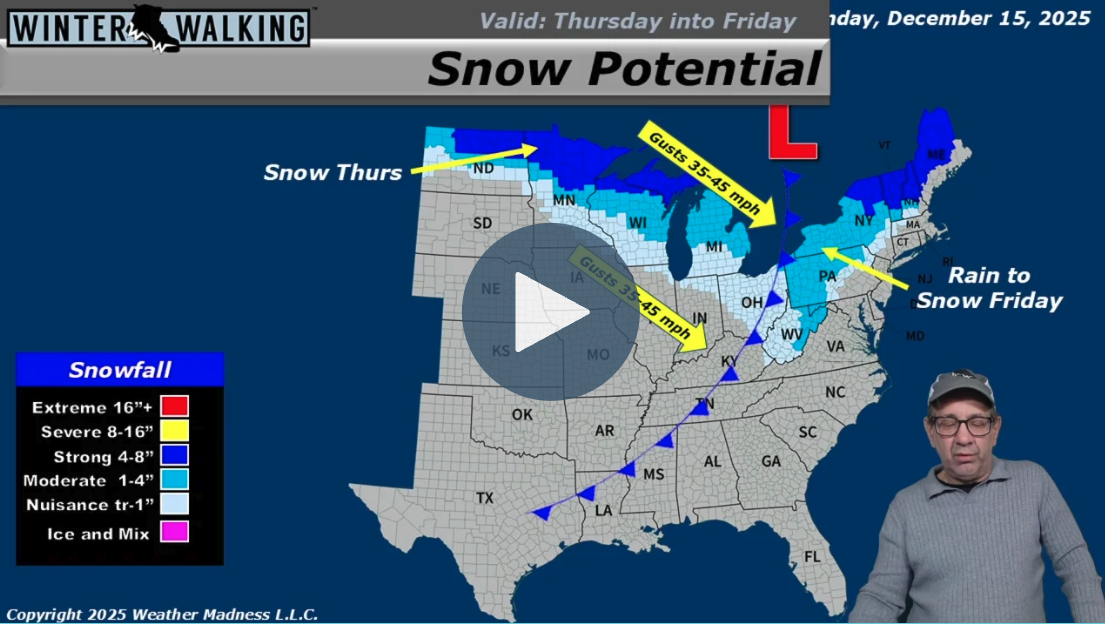
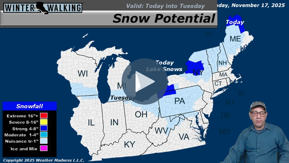
Lingering snow showers in the Northeast are moving away, making way for a new system originating from Wyoming. This incoming storm is expected to bring a swath of snow down through the Great Lakes and into the Appalachians. In the short term, lake-effect snow continues off Lakes Ontario and Erie, while a band of snow is forecast to track from Chicago and Milwaukee toward central Pennsylvania on Tuesday. Out west, a separate system is delivering heavy snow, measured in feet, to the Sierra Nevada, along with flooding rains in other parts of California. Looking at the long-range outlook, another […]
Continue Reading

Heavy Lake-Effect Snow Targets Buffalo, Potential "Big Snowstorm" Brewing for East Coast

11/10/25 9:27 AM
This winter weather forecast for November 10, 2025, presented by meteorologist Henry Margusity, details several active snow-producing systems across the eastern United States and Canada. The primary focus is on significant lake-effect snow developing around the Great Lakes, fueled by cold air moving over the warm lake waters. This setup is expected to create heavy snow bands, with a specific warning for the Buffalo, New York area, which could see heavy accumulation from Tuesday night into Wednesday. Meanwhile, an upper-level system in the Ohio Valley is generating snow showers that could track[…]
Continue Reading
DOWNLOAD THESE FREE ICE CLEAT GUIDES:
Top-5-Reasons-Why-Your-Company-Needs-A-Slip-&-Fall-Prevention-Program-1-1.jpg
3-Surefire-Ways-to-Reduce-Winter-Slips-and-Falls-1-REVISED.jpg
The-Most-Effective-Way-To-Reduce-Slips-and-Falls-on-Ice-and-Snow-1-1.jpg
How-to-Identify-the-Best-Ice-Cleats-for-Your-Organization-1.jpg
Learn-Why-Ice-Cleats-Alone-Will-Not-Eliminate-Your-Slips-and-Falls-1-NEW.jpg
An-Introduction-to-Ice-Cleats---Everything-You-Need-to-Know-1.jpg