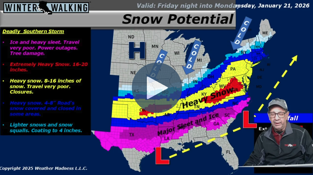
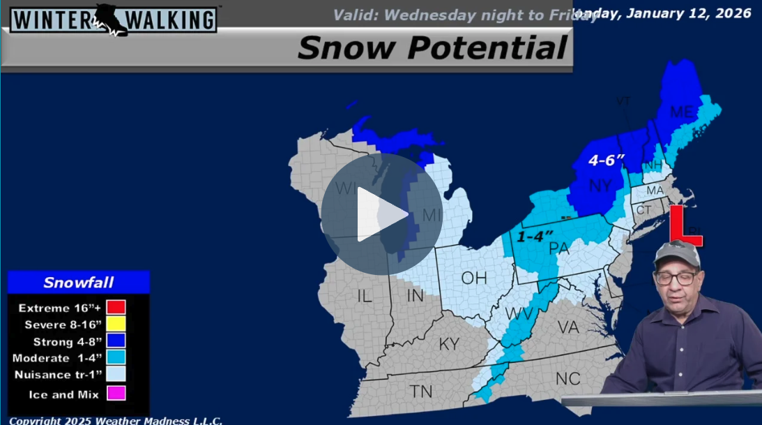
Meteorologist Henry Margusity forecasts a turbulent start to January 2026, beginning with a clipper system today that brings light snow to the Northeast. A more significant system is close behind, targeting the Great Lakes and Northeast from Tuesday night into Wednesday with heavier snow—particularly for Upstate New York and Northern Michigan—and a potential icy mix for New England. While a brief milder pattern may offer respite for some later this week, Margusity warns it will be short-lived as another storm targets the Midwest with roughly 4 inches of snow by Friday or Saturday. Looking furt[…]
Continue Reading
Meteorologist Henry Margusity forecasts active winter weather leading into the holiday, starting with a system tracking into the Northeast tomorrow, December 23rd. This disturbance is expected to bring a general 1 to 4 inches of snow to the region, with locally higher amounts possible and a risk of ice accumulation across the Appalachians and south-central Pennsylvania. The system will likely bring snow into New York City and potentially as far south as Baltimore before transitioning to a wintry mix. Concurrently, a "Pineapple Connection" is streaming moisture into the West, dumping heavy snow[…]
Continue Reading
Meteorologist Henry Margusity reports that the icy winter grip continues on December 15, 2025, with a potent cold front expected to sweep across the northern United States later this week. While current conditions show scattered snow showers in the Great Lakes and Appalachians, the approaching system for Thursday and Friday poses a significant threat of "flash freezes." As the front passes, precipitation is forecast to transition rapidly from rain to snow, accompanied by a sharp drop in temperatures—some areas are already seeing single digits—creating hazardous, slippery surfaces. Intense arct[…]
Continue Reading
Meteorologist Henry Margusity reports a significant shift in the weather pattern beginning December 8, 2025, characterized as a "Clipper Parade" that will send multiple fast-moving storm systems from the Midwest into the Northeast over the coming weeks. The current disturbance is already producing snow across parts of Virginia, West Virginia, and Kentucky, while a new clipper system is set to track through the Great Lakes. This pattern is ushering in a deep freeze, with a very cold air mass expected to lock into place and fuel continuous winter weather for the northern tier of the country. The[…]
Continue Reading
Meteorologist Henry Margusity reports on a significant winter storm developing on December 1, 2025, which is currently moving from the Central Plains into the eastern United States. After impacting Kansas City and Omaha, the system is expected to intensify as it tracks eastward, bringing a dangerous mix of snow and ice as far south as Northern Virginia and the Ozarks. While Washington D.C. and Dulles Airport may see a wintry mix before transitioning to rain, the system will largely remain a snow event for the northern regions, causing widespread travel delays. The Northeast is expected to rece[…]
Continue Reading
Meteorologist Henry Margusity reports a significant shift in the weather pattern starting November 24, 2025, driven by a rare early-season stratospheric warming event that is forcing cold air down from Canada into the United States. This "parade of storms" begins immediately with a system moving through the Northern Plains, followed quickly by a major storm targeting the Dakotas and Minnesota that could drop over a foot of snow. As the week progresses into Thanksgiving and Black Friday, the forecast calls for blustery conditions and lake-effect snow squalls, creating potentially hazardous trav[…]
Continue Reading


